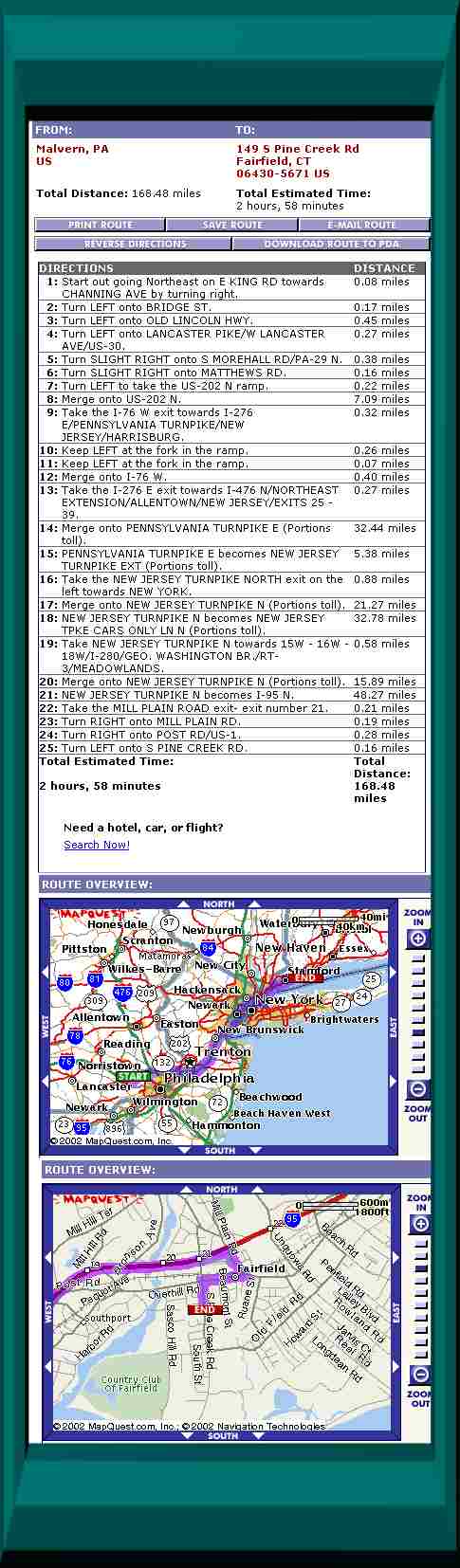
| DIRECTIONS |
DISTANCE |
 |
| 1: |
Start out going Northeast on E KING RD toward CHANNING AVE by turning right. |
|
0.08 miles |
|
| 2: |
Turn LEFT onto BRIDGE ST. |
|
0.17 miles |
|
| 3: |
Turn LEFT onto OLD LINCOLN HWY. |
|
0.45 miles |
|
| 4: |
Turn LEFT onto LANCASTER PIKE/W LANCASTER AVE/US-30. |
|
0.21 miles |
|
| 5: |
Turn SLIGHT RIGHT onto S MOREHALL RD/PA-29 N. |
|
0.40 miles |
|
| 6: |
Turn SLIGHT RIGHT onto MATTHEWS RD. |
|
0.22 miles |
|
| 7: |
Merge onto US-202 N via the ramp- on the left. |
|
7.09 miles |
|
| 8: |
Take the I-76 W exit toward I-276 E/PENNSYLVANIA TURNPIKE/NEW JERSEY/HARRISBURG. |
|
0.32 miles |
|
| 9: |
Keep LEFT at the fork in the ramp. |
|
0.26 miles |
|
| 10: |
Keep LEFT at the fork in the ramp. |
|
0.07 miles |
|
| 11: |
Merge onto I-76 W. |
|
0.40 miles |
|
| 12: |
Merge onto PENNSYLVANIA TURNPIKE E/I-276 E toward I-476 N/NORTHEAST EXTENSION/ALLENTOWN/NEW JERSEY/EXITS 25 - 39 (Portions toll). |
|
32.44 miles |
|
| 13: |
PENNSYLVANIA TURNPIKE E/I-276 E becomes NEW JERSEY TURNPIKE EXT (Portions toll). |
|
5.38 miles |
|
| 14: |
Take the NEW JERSEY TURNPIKE NORTH exit on the left toward NEW YORK. |
|
0.88 miles |
|
| 15: |
Merge onto NEW JERSEY TURNPIKE N (Portions toll). |
|
21.27 miles |
|
| 16: |
NEW JERSEY TURNPIKE N becomes I-95 N (Portions toll). |
|
45.22 miles |
|
| 17: |
Take I-95 EXPRESS LN N/NEW JERSEY TURNPIKE N toward G WASHINGTON BR. |
|
0.52 miles |
|
| 18: |
Merge onto NEW JERSEY TURNPIKE N. |
|
3.55 miles |
|
| 19: |
NEW JERSEY TURNPIKE N becomes I-95 N. |
|
48.28 miles |
|
| 20: |
Take the MILL PLAIN ROAD exit- exit number 21. |
|
0.21 miles |
|
| 21: |
Turn RIGHT onto MILL PLAIN RD. |
|
0.19 miles |
|
| 22: |
Turn RIGHT onto POST RD/US-1. |
|
0.28 miles |
|
| 23: |
Turn LEFT onto S PINE CREEK RD. |
|
0.16 miles |
|
|
Total Estimated Time: |
|
Total Distance: |
| 2 hours, 48 minutes |
|
168.04 miles |